Not all severe winds are tornadic
It was the morning of June 24th, 1975. Thunderstorms were rolling over New York City. At the J.F. Kennedy Airport, two planes were preparing to make their descent. Only one touched down safely.
Eastern Airlines Flight 66 radioed the control tower, warning of high turbulence. Despite the bumpy conditions, they got the green light on the land. As Flight 66 approached the runway, it was swept downwards by strong winds. The left plane wing tore in seconds, and when the plane crashed, the impact shattered it into pieces. 124 people were on board, all but 11 perished in the crash.
That wasn't the first plane to crash under these circumstances.
Scientists estimate 20 other plane crashes were caused by the same thing, downbursts, which resulted in over 500 deaths.
After the crash at the J.F.K. airport, Dr. Ted Fujita, also known as Mr. Tornado, was called in to investigate what went wrong.
Fujita already had quite a reputation. He revolutionized meteorology through his research on tornadoes and severe thunderstorms. It is because of him we have the term wall cloud and multi-vortex tornado. Fujita also developed the classification system for tornadoes, which scales them based on their wind speed and damage.
In came Fujita with his detective skills. He studied the radar imagery, storm reports, flight records, and interviewed pilots who had landed safely before the deadly crash of Flight 66. He began to suspect meteorological phenomena, known as a downburst, had occurred.
His discovery of downburst transformed the airline industry. Radars are now at nearly every airport. Pilots and air traffic controllers go through extensive training on how to detect and maneuver through downbursts. The last time we had a plane crash caused by a downburst was in 1994.
So what is a downburst?
During the early stage of a thunderstorm, the updraft sucks in air which grows the storm vertically. As the storm strengthens, hail and raindrops form.
The storm matures when it starts to precipitate, and an updraft and downdraft are present. Dry air enters the backside of the thunderstorm. Because the air inside downdrafts is considerably cooler and denser than air in updrafts, it sinks. All of the precipitation and hail within the core of the downdraft sinks as well.
Downbursts are downdrafts that produce strong straight-line winds at the surface. It's important to remember that all downbursts are downdrafts, but not all downdrafts are downbursts.
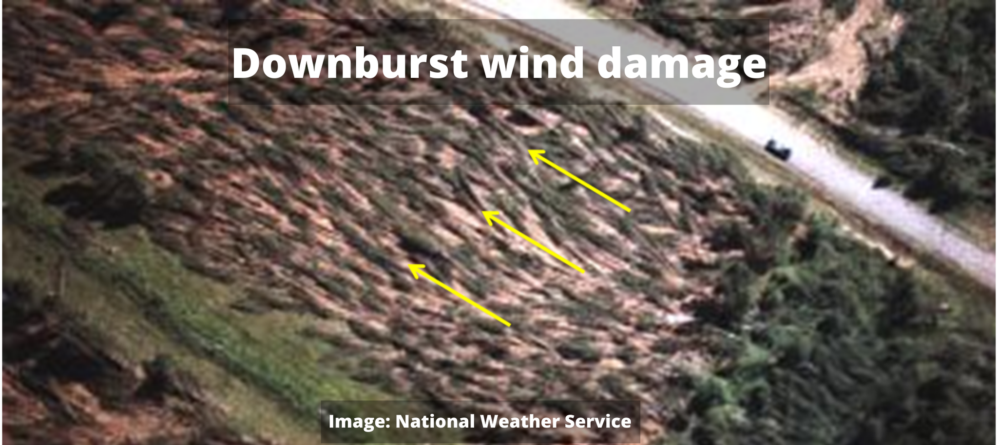
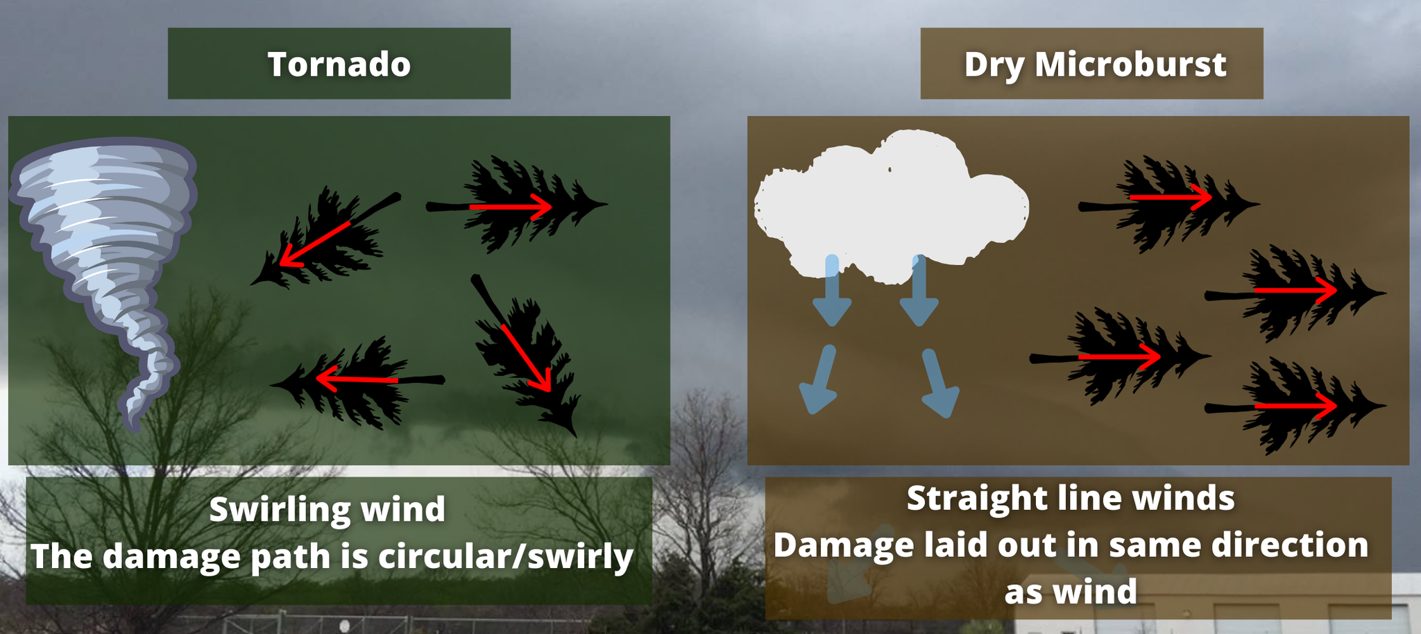
To visualize a downburst, think of what happens when you turn on a faucet. The water rushes down, hits the bottom of the sink, and shoots out in all directions. Downbursts do the same thing. Lower relative humidity beneath the storm increases the speed of the downburst, which contributes to stronger wind gusts. These winds can have the strength of an EF-0 (65 - 85mph) or EF-1 (85mph - 110mph) tornado. The damage is often mistaken for tornadic damage. However, tornadoes are caused by a very different process and have a swirly wind pattern. Winds from a downburst are straight.
Downbursts can further be classified as a macroburst, dry microburst, or wet microburst. The classification depends on the type of air falling and the radius of the winds.
A macroburst occurs when the descending air spread out more than 2.5 miles. In a microburst, the spreading air is confined to an area less than 2.5 miles.
Further, Fujita discovered two types of microbursts, wet and dry microbursts. In a dry microburst, the precipitation evaporates into the downdraft. When the air hits the surface, it is nearly free of precipitation.
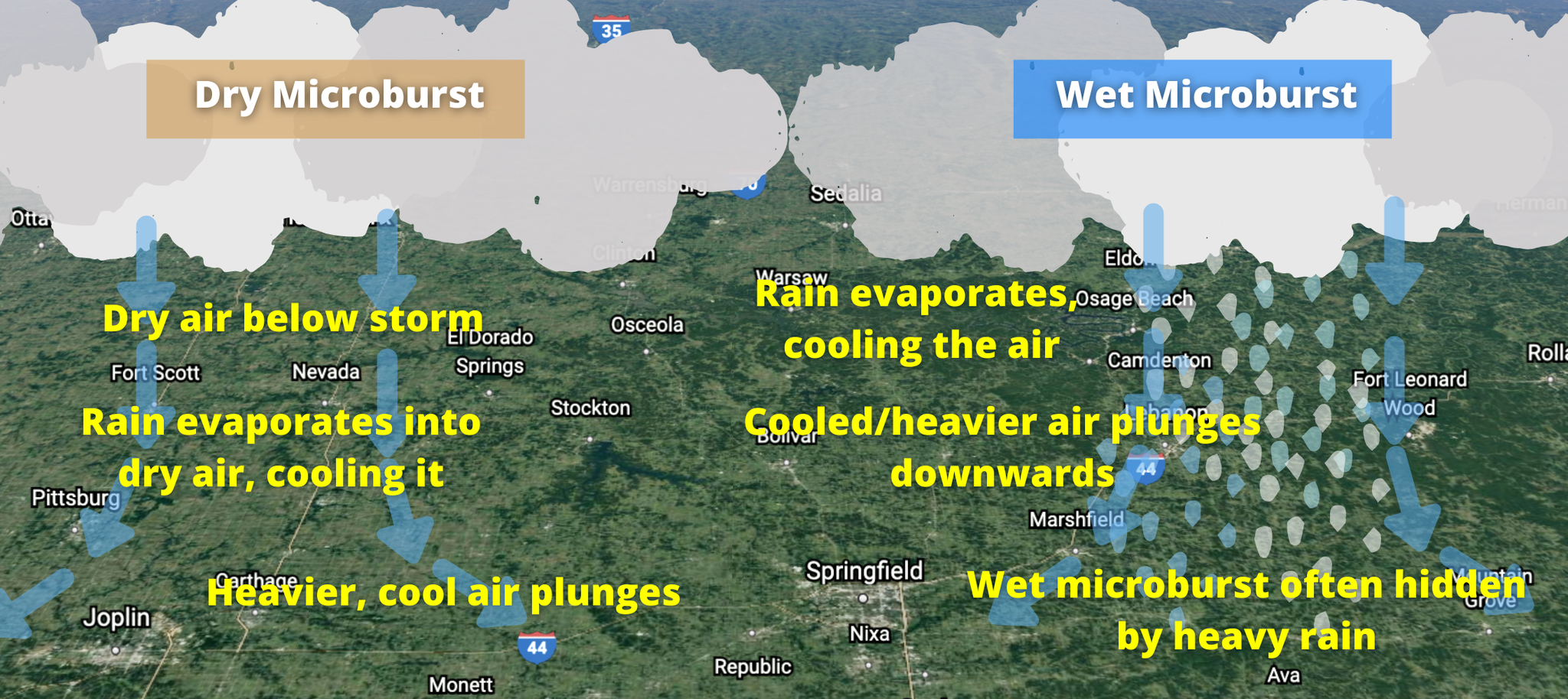
A wet microburst needs saturated air near the surface and dry conditions aloft, thus preventing precipitation from evaporating as it falls. Heavy rain often accompanies a wet microburst.
Last week, I discussed heat bursts, which you can read by clicking HERE. You may have gathered that microbursts and heat bursts are very similar. They're both caused by dry air in storms leading to descending motion. The main difference is where the dry air originates.
Heat burst origins are much higher in the air compared to a microburst. Secondly, microbursts do not provide the same spike in temperatures as a heat burst. Finally, by the time the heat burst has formed, the storm has just about already dissipated. So there is very little precipitation in the burst.
Regardless of the type of burst, they are all capable of producing near tornado-strength winds, leading to horrific damage. For airplanes, they are life-threatening events. Thankfully, forecasters and airlines now have methods for detecting these types of bursts.

0 Comments Add a Comment?