Warning! Acronyms ahead
Something you should know about meteorologists, we love acronyms. This is a good thing because saying mesoscale convective system (MCS), quasi-linear convective system (QLCS), mesoscale convective complex (MCC), or mesoscale convective vortex (MCV), is a mouthful. While they share many similarities in terms of the severe weather they produce (strong winds, hail, tornadoes, and heavy rain), they have distinct characteristics.
Mesoscale Convective System
This is an umbrella term for QLCS, MCC, and MCV. An MCS describes a collection of thunderstorms all acting as one system. These complexes are large, with the width of an entire state and length spanning thousands of miles. They can last up to 12 hours and provide widespread damage. We had such a system come through late Friday night that brought severe storms to the Ozarks but more especially to the southeast, leading to one fatality in southern Louisiana.
Video courtesy of College of DuPage radar archive.
Just like regular thunderstorms, they need moisture, lift, and instability for their formation, with wind shear helping to increase the organization and longevity of the complex. They maintain their strength as the air continues to rise and as new thunderstorm updrafts develop.
MCS is most common in the spring and summertime. Despite the damages caused, they are necessary for providing much-needed rainfall to the Great Plains and the Midwest, rain essential for the agriculture industry.
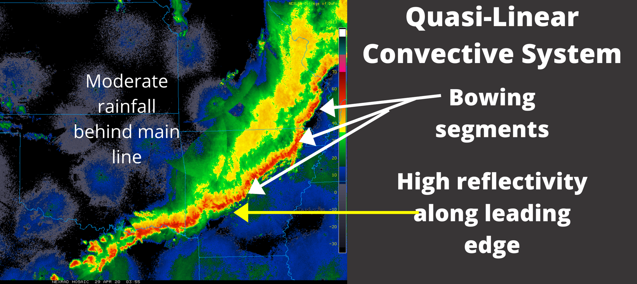
Quasi-Linear Convective System
QLCS falls under the MCS umbrella. Basically, they are a type of MCS with more organized convection, forming a semi (or quasi) linear line, and advancing movement. To be classified as a QLCS, they must be at least three times longer than they are wide, with a length of around 100 or more kilometers. Squall lines, bow echos, and Derechos are a type of QLCS.
You will find high radar reflectivity along the leading edge of a QLCS. Remember what all the colors mean? You can read about radar reflectivity by clicking HERE. This high reflectivity indicates a region of intense rainfall and hail, with moderate rain on the backend. The most prominent feature of a QLCS is a bow echo caused by strong winds that blow in from behind the storm, pushing a section of the storm forward and creating a bow feature. Ahead of the mainline, a strong downdraft will create widespread wind damage. With winds gusting upwards of 100mph in the downdraft, they can produce as much, if not more, damage as an EF-0 or EF-1 tornado. You can have several bowing segments within one line of thunderstorms.
Spin-up tornadoes are common with QLCS lines. While these tornadoes are short-lived, they can be just as impactful as tornadoes produced by supercell thunderstorms. Causing damages and, in the worst cases, leading to fatalities. Little notches embedded within the storm (as described in my previous post HERE) are an indication there is rotation and potentially a tornado.
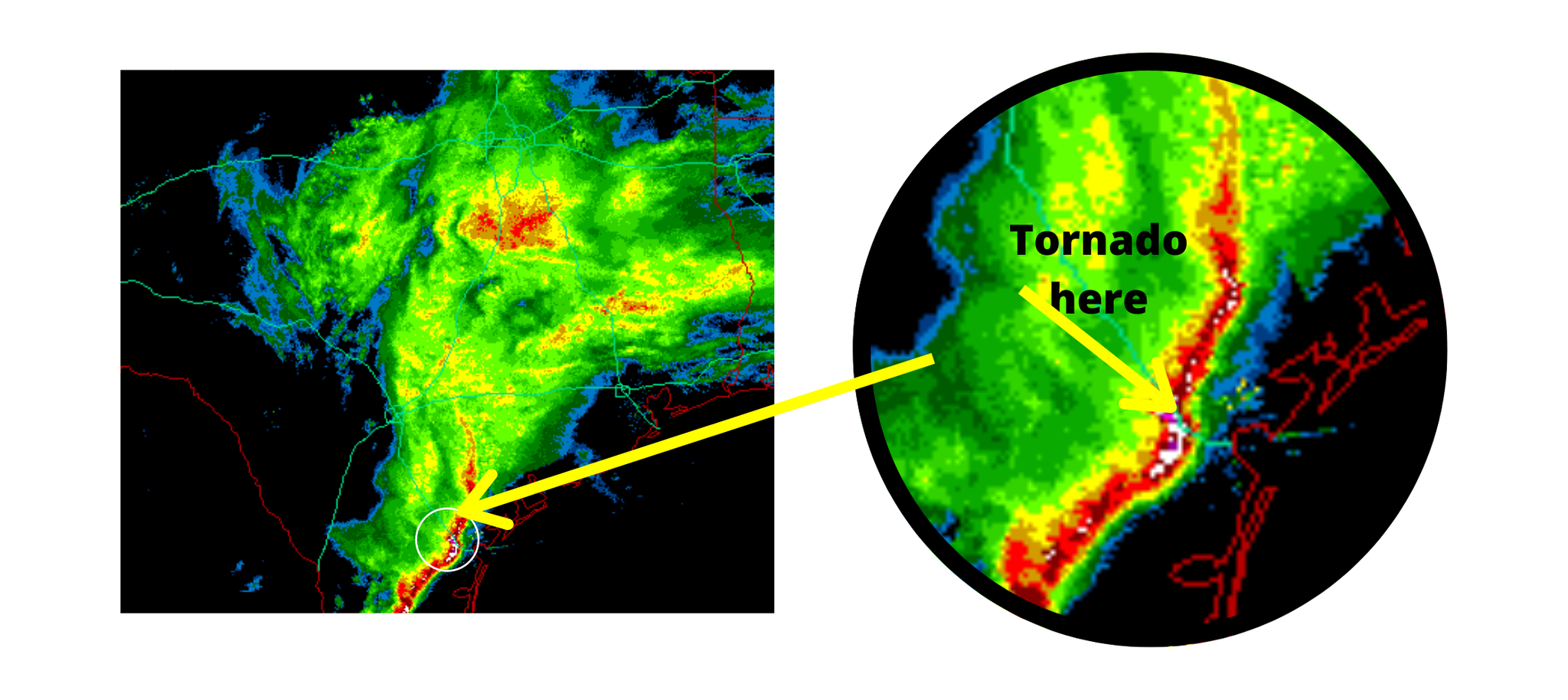
Because these tornados are short-lived, they pose an added challenge for meteorologists. The tornado can form in-between radar scans and may die out before the radar even picks up the rotation. To help combat this, when a severe thunderstorm warning is issued for a QLCS a 'tornado possible' tag is included within the warning text. This way, people are still warned that there is potential for a tornado, evening without a tornado warning.
Mesoscale Convective Complex
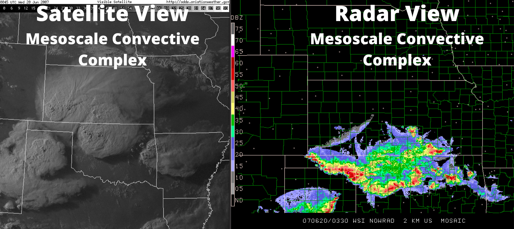
For a complex to be classified as an MCC, it must meet particular size and duration criteria. First, their cloud top temperatures must be -32C or less and cover an area over 100,000 square kilometers (or over 38,000 square miles). Second, their coldest cloud top temperatures must be at least -52C covering an area of 50,000 square kilometers (or 19,000 square miles). Thirdly, they will have an elliptical or circular shape, and their duration must last at least 6 hours. Complicated right? They are identified based on satellite, infrared, or water vapor imagery and are more common during the late night or early morning hours. The photo below has a side-by-side view of satellite and radar imagery from an MCC along the Kansas and Oklahoma border on June 7th, 2007.
Mesoscale Convective Vortex
An MCV is a low-pressure center within an MCS that pulls winds into a circular pattern. An MCV has core between 30 and 60 miles wide, a depth of 3 miles, and lasts upwards of 12 hours. Because of their persistence and ability to survive even after their parent MCS dies, they have the capability of fueling a second thunderstorm outbreak. If you see a large swirly feature on radar or satellite imagery, that is likely an area of low pressure caused by the MCV.
On an important note, while they are often called land hurricanes, they are not hurricanes. While their rotation mimics that of a hurricane, because of the rotating thunderstorms and even an eye-looking center structure, these storms are not tropical. They are not hurricanes but rather a rotating vortex. Additionally, a hurricane and MCV have very different development processes.
Consider the following radar imagery of an MCV that occurred across Minnesota and Iowa on June 29th. Initially, just a weak vortex, but you can still pick out the swirly rotation around the low pressure at the beginning of the video (0:0 to 0:06). Notice how the vortex strengthens, causing the development of new thunderstorms. The MCV is acting as a seed for new storms to grown. Watch the video around 11 seconds in to see the new thunderstorm development. Eventually, a distinct line of strong thunderstorms with bowing segments propagated eastward. Those storms dumped heavy rain in Minnesota leading to flash flooding.
_______________________________________________________________________________________
Whew, that was a lot to go through, wasn't it? Here's the deal, you don't necessarily need to be a pro at defining the storms. If you see them coming, however, you need to get inside. As I mentioned earlier, these storms are capable of producing all modes of severe weather, which is not something to be caught out in. Be safe, pay attention, and act when severe weather is near. If you follow these guidelines, you should come out fine.

0 Comments Add a Comment?