Q&A - Ask away! I'll answer Pt. 2
I was blown away by the questions this week. Since there were too many to answer in one post, I’ll be breaking up the questions between two weeks. If your question is not answered below, check back next Friday!
You can submit questions in the comment section of this post, or email me directly through the website contact form. Questions can also be sent through any of my social media platforms. Find me @leahwx11 on Facebook, Twitter, and Instagram. If I miss your question, keep commenting on futures posts! I want ALL your questions answered.
Question: How to anticipate the duration of rain depending on if it were cold front or warm front-driven.
I love this question! First off, remember that warm air rises because it is less dense than cold air.
A cold front is an air mass of cold or cooler air moving into an environment of warmer air. The density of cold air helps the front move quicker. The warm air rises rapidly above the cold air and creates a strong lifting mechanism for thunderstorms. When a cold front advances, you'll often experience quick-moving showers and thunderstorms (often violent). Cold fronts on weather maps have a blue triangle line. They typically move from northwest to southeast.

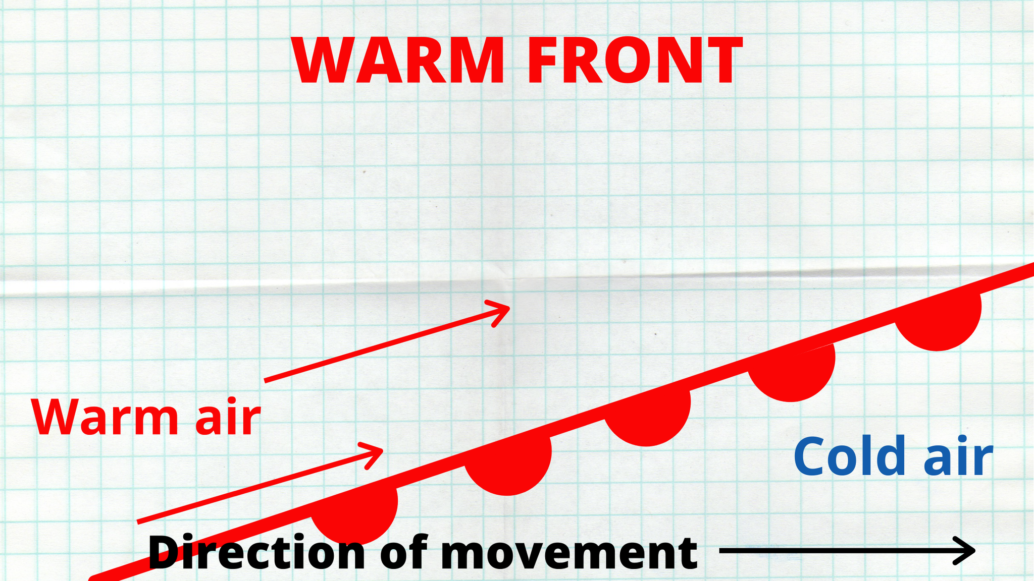
Warm fronts move about half as fast as cold fronts. There are a couple of factors influencing this. Warm fronts are less dense which slows them down. As a warm front advances, the warm air pushes into and above the cold air, but the slope of the warm front is lower, resulting in a slow ascent. This also contributes to a slower movement. Typically, when a warm front moves in, a longer duration of showers can be expected. You’ll see them on weather maps portrayed as a red line with red half circles. They typically move from southwest to northeast.
While warm and cold fronts are the most common, they aren’t the only type of fronts that produce rainfall. Stationary fronts occur when the cold air overtakes the warm air and stalls out. They behave like warm fronts. Winds along the front are parallel to the front itself, so there is little movement. Any rain forming along the front also remains stationary.
Additionally, the duration of rainfall is also impacted by winds higher in the atmosphere. If we have strong winds aloft, this aids in fronts and storms moving faster, acting to push storms through an area. Weaker winds aloft can lead to slower frontal and storm movement.
Question - Is it just the temperature that causes moisture to fall as freezing rain/hail instead of snow?
And a linked question: It always seems like the temp will stay just above freezing if it's raining. Like it's trying not to snow. It stops raining when the temps get to 32 it seems, or it warms up so it's above 32, more often than not. Like there's some threshold. Is there anything to that?
The type of precipitation expected does depend on the temperature. Other factors such as the thickness of the atmosphere, moisture availability, terrain, location of the low pressure, also play a role. To answer these two questions, I’m just going to focus on the temperature impacts. As a storm moves in, if the air is above 32°F the precipitation falls as rain. If the air is below 32°F the precipitation falls as snow. You can consider 32°F to be the threshold, but there are instances where this does not hold. Take Colorado, for example, it is not uncommon for snowfall when the surface temperature is 40° F. In this case, the air above the surface is well below freezing.
Precipitation type is a factor of the temperatures at the surface and up to the cloud base. Note: Clouds are composed of tiny ice crystals or water droplets. When these particles combine and become too heavy, they fall to the ground. Let’s break that process down:

Snow - As ice crystals collide they grow in size and form snowflakes. Eventually, becoming too heavy for the cloud to hold and fall to the ground. If all layers of the atmosphere are below 32°F, they land as snow.
Sleet - A small layer of warm air wedges in between the cold layers below the cloud base. The warm air melts the snow as it’s falling. However, the crystals re-freeze into sleet as they pass through another layer of cold air before landing. Sleet look like tiny ice pellets and often get mistaken for hail.
Freezing rain - Similar to sleet, a warm layer exists somewhere below the cloud base. In this scenario, the warm layer is thicker with a shallow cold layer closer to the surface. The precipitation re-freezes on the ground.
Rain - Air temperatures up to the cloud base are above freezing. All the ice crystals melt when falling.
Hail - This occurs in strong thunderstorms. Hail forms when water vapor is lifted to the top of thunderstorms into a region of cold air. Strong updrafts suspend hailstones in the storm. Hail grows as more water vapor freezing on the stones. Eventually, the hail will become too heavy for the updraft and fall. Hail size ranges from as small as a pea to as large as a grapefruit.
Question - When is spring coming? Tired of cold and muddy conditions?
You’re not alone! I have been tired of the cold since winter started. Cold weather is not my favorite.
Spring officially starts on March 20th (50 days from today), which is the spring equinox. While temperatures will gradually warm as we approach spring, it will still be muddy as we’ll also enter our rainy season.
The average high temperature for Springfield in January is about 43 degrees. By February, the average temperature rises to 48 degrees. In March, the average high temperature reaches the 50s.
We still have a ways to go before the temperatures trend warm. Keep in mind these are averages but not a guarantee. There will be many more cold days before we reach spring.
Click HERE to view more climate data and average monthly temperatures.
For long-range weather outlooks, click HERE for the Climate Prediction Center's website.

1 Comment Add a Comment?
Rich M
Posted on Jan. 30, 2021, 4:57 p.m.
Great responses Leah!
So is there nothing to the idea that snow causes the air to warm a little if it's close to the freezing point? Maybe it's just coincidence and we live on the border of places where it mostly snows in winter, vs mostly rains. I don't much like cold either, but if it's gonna be cold, at least we could get some snow. Can we place an order for that with you? :) thanks again!