Breaking down the threats- Severe weather pt. 1
This week is Severe Weather Awareness Week in Missouri, a week dedicated to understanding our risk for severe weather and how we can prepare for the upcoming severe weather season. In honor of this week, I'll be breaking down some of the threats we are all too familiar with: Strong storms and tornadoes. This post is just Part 1 of a three-part series on severe weather.
Heads up meteorologists - Spring is coming
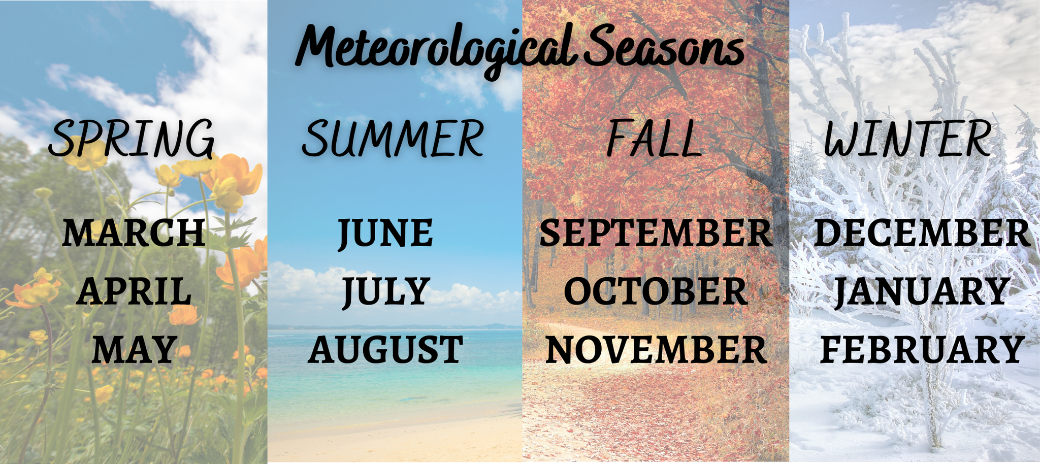
March 1st marks the start of meteorological spring, which is earlier than the astronomical spring that begins March 22nd.
Meteorologists break down seasons by months, grouping three months together based on their annual temperature cycles and our calendar. Astronomical seasons depend on the Earth’s rotation around the sun. You can read more about this rotation around the sun in one of my previous blog posts by clicking HERE.
When March 1st rolls around, meteorologists prepare for an increased threat for severe weather. While severe weather can happen any time of the year, it peaks during springtime.
What makes spring so special?
Spring brings all the severe weather ingredients together with greater intensity (as can be seen in the image below). With the changing seasons, the atmosphere changes as well. During the spring, more direct rays from the sun lead to more warming at the surface. Aloft there still exists slightly cooler air. This mix of warmer air at the surface and cooler air aloft builds atmospheric instability. Warmer air also holds more moisture, a second ingredient for storms that increases over the next few months.
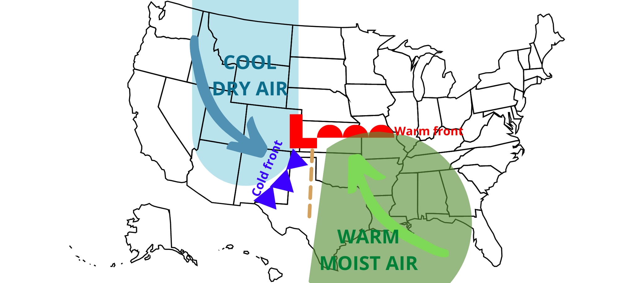
The third ingredient is lift, or upwards motion. Fronts, daytime heating, terrain, and outflow boundaries from other storms are all lifting mechanisms.
Finally, the jet stream also experiences changes in the spring. The jet stream resides about 6 miles above the surface and is a region of fast-moving winds caused by the temperature and pressure differences aloft. This jet stream is wavier during springtime, leading to the movement of air masses and storms.
Breaking down the threats - types of thunderstorms
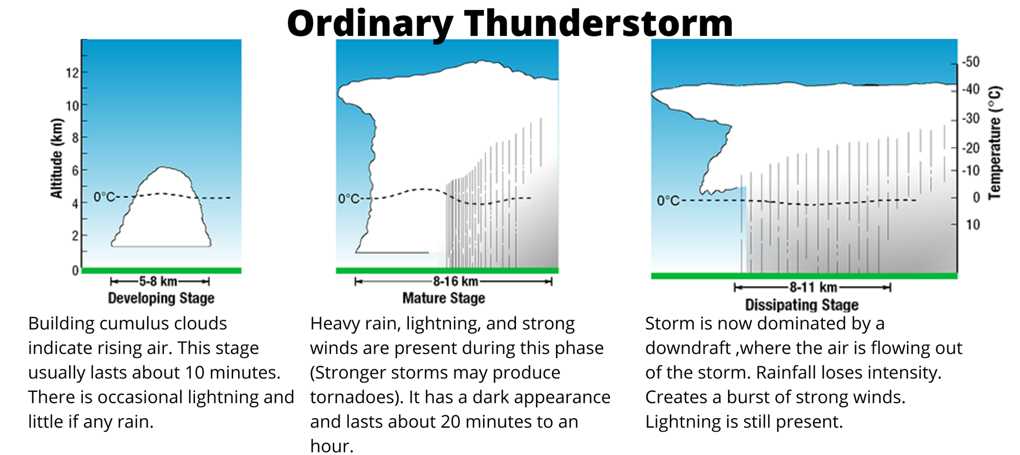
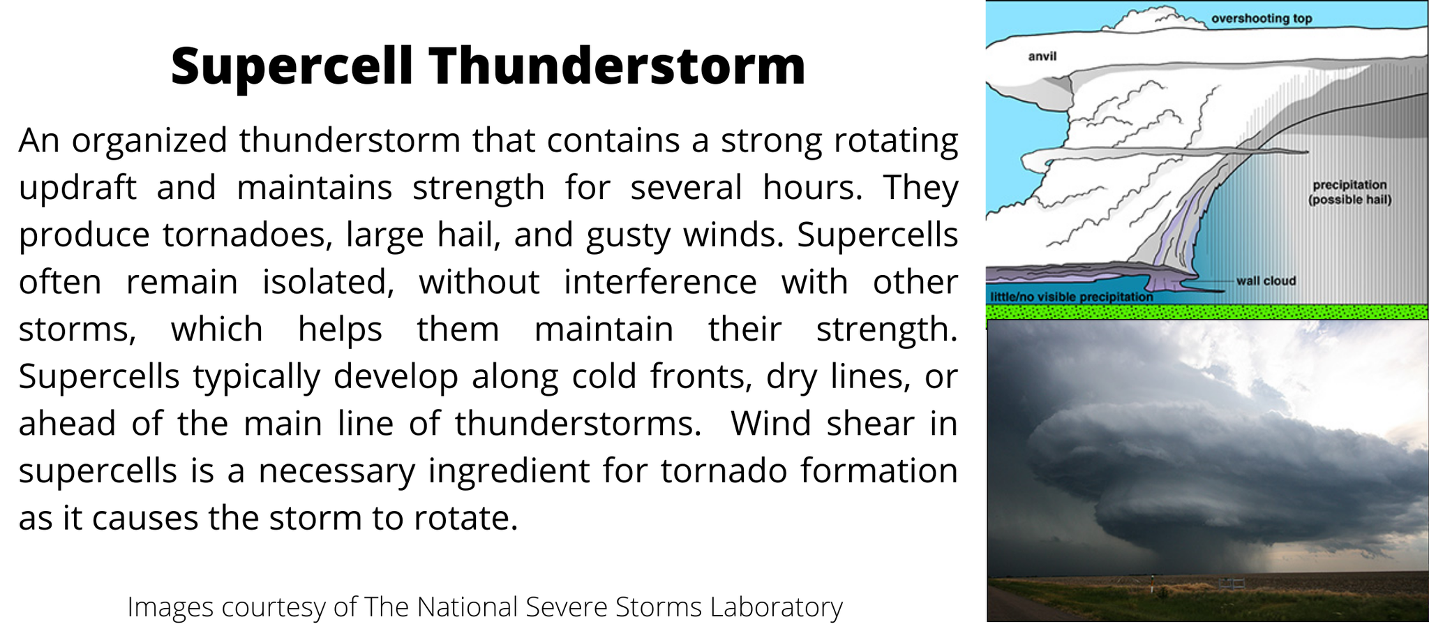
There are two types of thunderstorms, ordinary and severe, which can further divide into subcategories. Ordinary thunderstorms last about an hour or so. While they stay below severe limits, some may produce the occasional small hail. Severe thunderstorms come in the form of supercells or a line of thunderstorms such as bow echos, squall lines, mesoscale convective systems, and Derechos.
A storm is classified as severe when there is hail one inch or greater, winds gusting more than 50 knots (57.5 mph), or there is a tornado.
The following images break down some of these storms and their common characteristics.
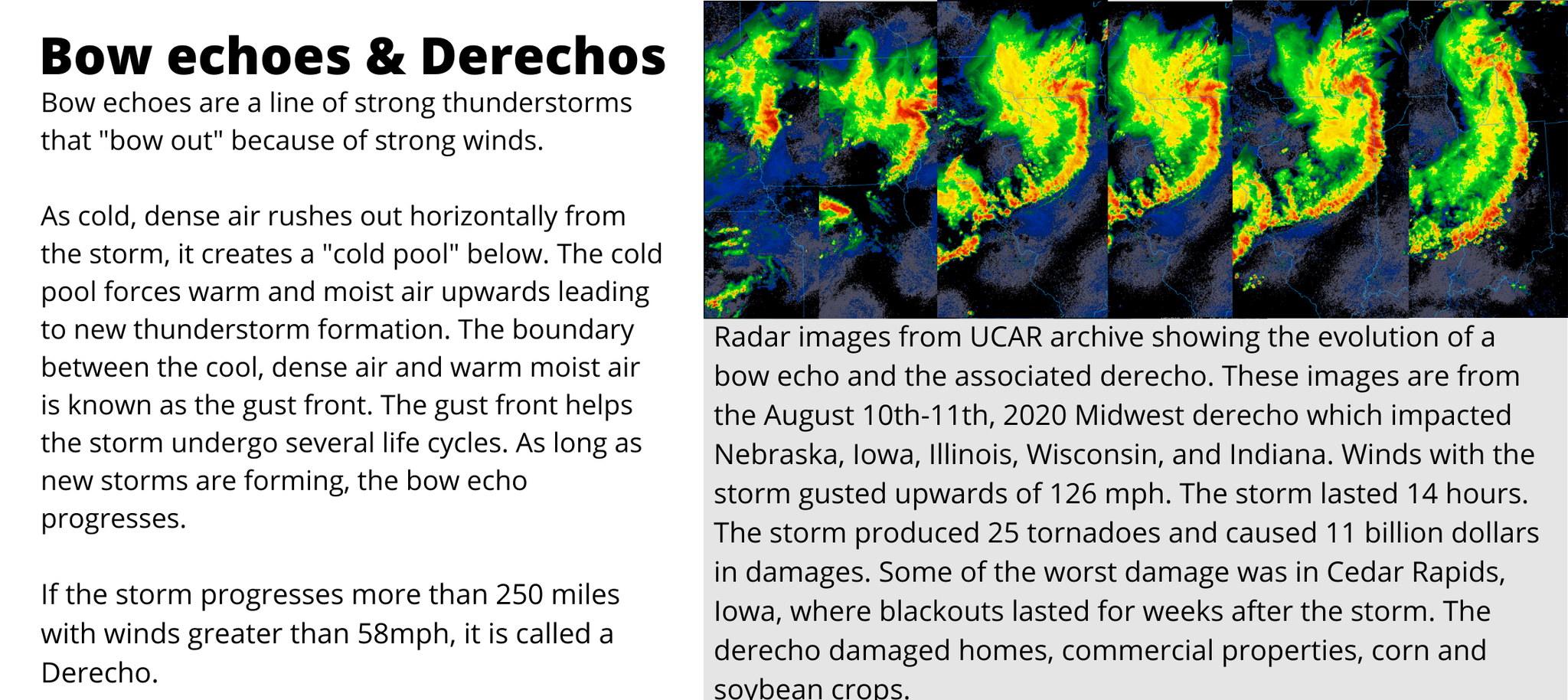
For more on bow echoes, click HERE.
Breaking down the threats - What is a tornado?
Tornadoes are violently rotating columns of air extending from a thunderstorm to the ground. The strongest tornadoes may have wind speeds upwards of 300mph. How do they form? First, they need a thunderstorm, such as a supercell. These storms are the most violent. They can last from two to four hours, are isolated in nature, and have a rotating updraft called a mesocyclone. Another characteristic of a supercell is the rotating wall cloud found at the base of the storm.
Remember the ingredients for a thunderstorm? Lift, moisture, and instability. Well, wind shear is a fourth ingredient needed for supercells. Wind shear is a wind change with height. Wind shear aids in displacing the supercell's updraft from the downdraft and tilting the thunderstorm.
A separate updraft and downdraft region increases the storm's longevity because it limits how much rain-cooled air from the downdraft is caught in the updraft. The separation also causes the supercell to rotate, creating the mesocyclone. Wall clouds are a good indicator of the storm's strength and location of the mesocyclone. When the updraft and downdraft are no longer separated, the storm dies.
A tornado forms when horizontal winds flowing into the storm rotate clockwise with height due to the wind shear. As the winds grow in strength, the axis of rotation is drawn inward. Think of a figure skater spinning faster when drawing their arms closer instead of being outstretched. Eventually, these horizontal winds are tilted vertically because of the updraft and mesocyclone. A funnel cloud may form within the rotating wall cloud. The moment the funnel cloud touches the ground, we get a tornado. By definition, to be a tornado it must touch the ground. Saying, “tornado on the ground," is redundant.

Supercells are not the only tornado-producing storms. We often see them embedded within lines of strong thunderstorms because of smaller scale rotation. Tornadoes forming within squall lines or bow echoes are also common. On average there are around 1,200 tornadoes a year in the U.S. In Missouri, we see on average about 30 tornadoes a year, and Arkansas sees on average about 39 tornadoes.
Next week:
Tornadoes are rated based on their wind speed and the damage they cause. Next week I will breakdown how tornadoes are classified and also go into the differences between tornado and severe weather watches, and warnings. It is essential to understand these warnings and the steps to take when each one is issued.
Coming March 16th:
While tornadoes and severe storms steal the attention, they are not the only threat we face here in the Ozarks. Flooding and strong winds are what affect us most. Check back in two weeks as I will break down the risks associated with flooding and strong winds.

0 Comments Add a Comment?