BREAKING NEWS- Pretty colors heading our way
Maybe you were wondering why I didn’t post Tuesday? Well, that’s because I was taking some much-needed time off with my family for Easter. I haven’t celebrated the season with my family in three years, so when it was safe to do so this Easter, I jumped at the opportunity. I completely disconnected and had a wonderful break.
Last week I covered the basics of radar and what the radar colors mean. I also compared several radar apps and explained how to determine when a storm will move into your backyard. You can read that post by clicking HERE.
I want this blog post to provide a diagnostic guide for several thunderstorms we see here in the Ozarks. As those pretty colors head your way, you will be able to recognize the storm's distinguishing features.
Single-cell thunderstorms- AKA, popcorn thunderstorms
Whenever the forecast calls for pop-up thunderstorms, these are usually single cell (or popcorn) thunderstorms. They are weak and brief storms. They “pop up” because of daytime heating and are very typical on a summer day. So if you are caught by surprise because a sudden storm developed over you, dumped rain for a few minutes, then cleared out, that is a single-cell thunderstorm.
Consider the following radar image from a few single-cell thunderstorms in Missouri on July 3rd, 2020. Looks like popcorn, right? It makes me hungry thinking about it. Small in size and overall weak, they don’t move much, and typically have a life cycle of about thirty minutes. Occasionally, they can gain enough strength to produce a downburst of wind or some small hail.
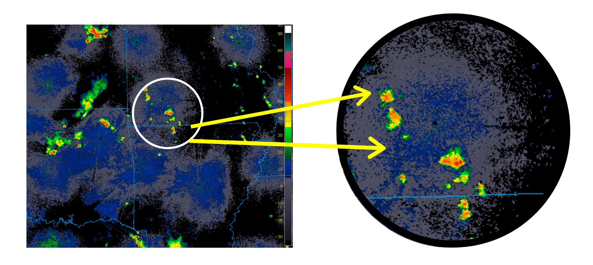
The following timelapse is from the same July 3rd, 2020 storm, a great example of the storm's lifecycle. Initially, the storm gains strength, produces some locally heavy rain, before becoming sheared apart and dying out. Take note of how the storm did not move much.
Multi-cell thunderstorms- feeder cells
Multi-cell thunderstorms are a family of cells existing at different stages of their lifecycle. While the individual storm may last anywhere from a half-hour to an hour, they keep the system as a whole strong, and the complex may last for several hours. These storms often form along gust fronts, which is an area of strong winds. The gust front produces new thunderstorm updrafts that act to feed the main complex of storms, undergoing the stages of strengthening and eventually dissipating. Multi-cell clusters will last as long as new thunderstorm updrafts are born and feed the main complex. They can be strong, producing all modes of severe weather and may lead to flooding.
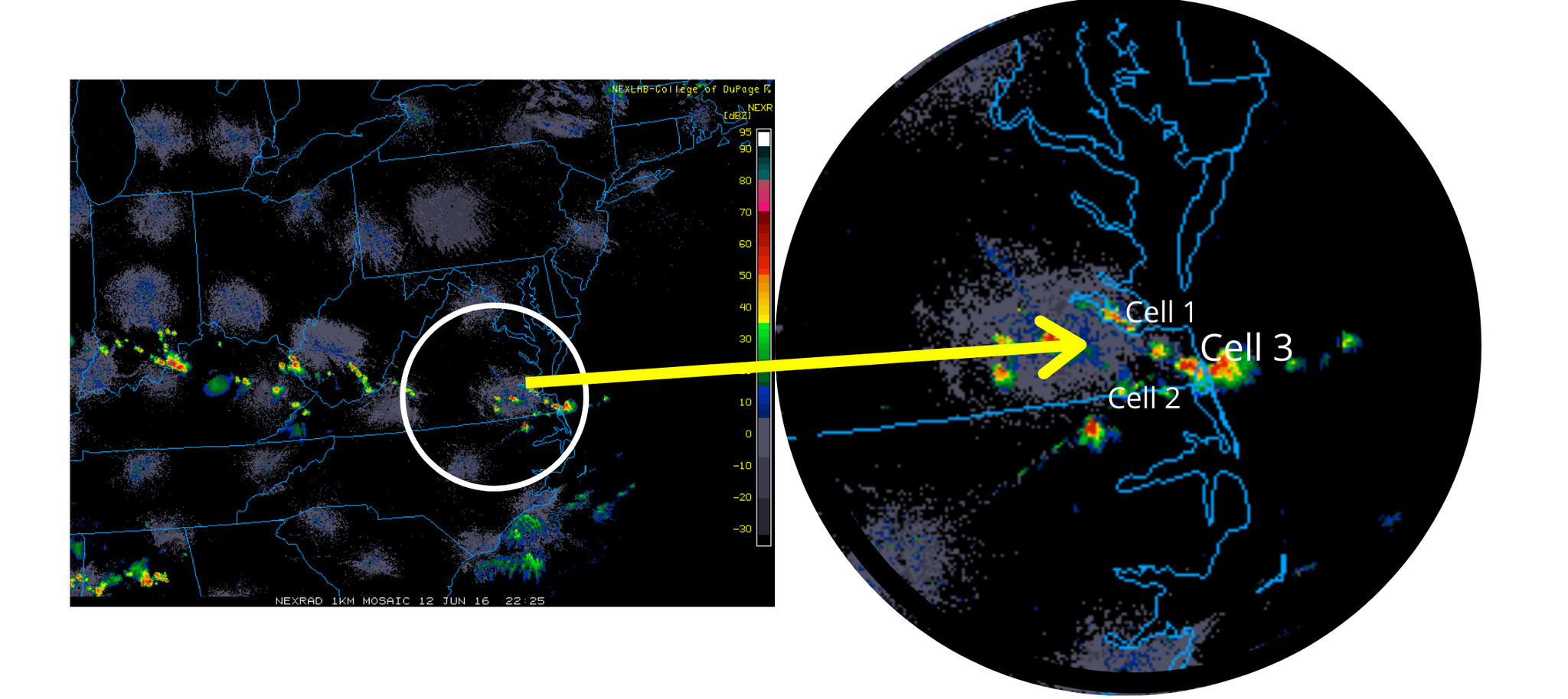
Consider the following radar image. Cell 1 and cell 2 are the feeder cells, maintaining the strength of the complex are in the developing stage of their lifecycle. Cell 3 is in the mature stage. You can read more about thunderstorm life cycles by clicking HERE.
Supercells
Supercells are organized thunderstorm which contains a strong rotating updraft and maintains strength for several hours. They produce tornadoes, large hail, and gusty winds. Supercells often remain isolated, without interference with other storms, which aids in maintaining their intensity. Supercells typically develop along cold fronts, dry lines, or ahead of the mainline of thunderstorms. Wind shear in supercells is a necessary ingredient for tornado formation as it causes the storm to rotate.
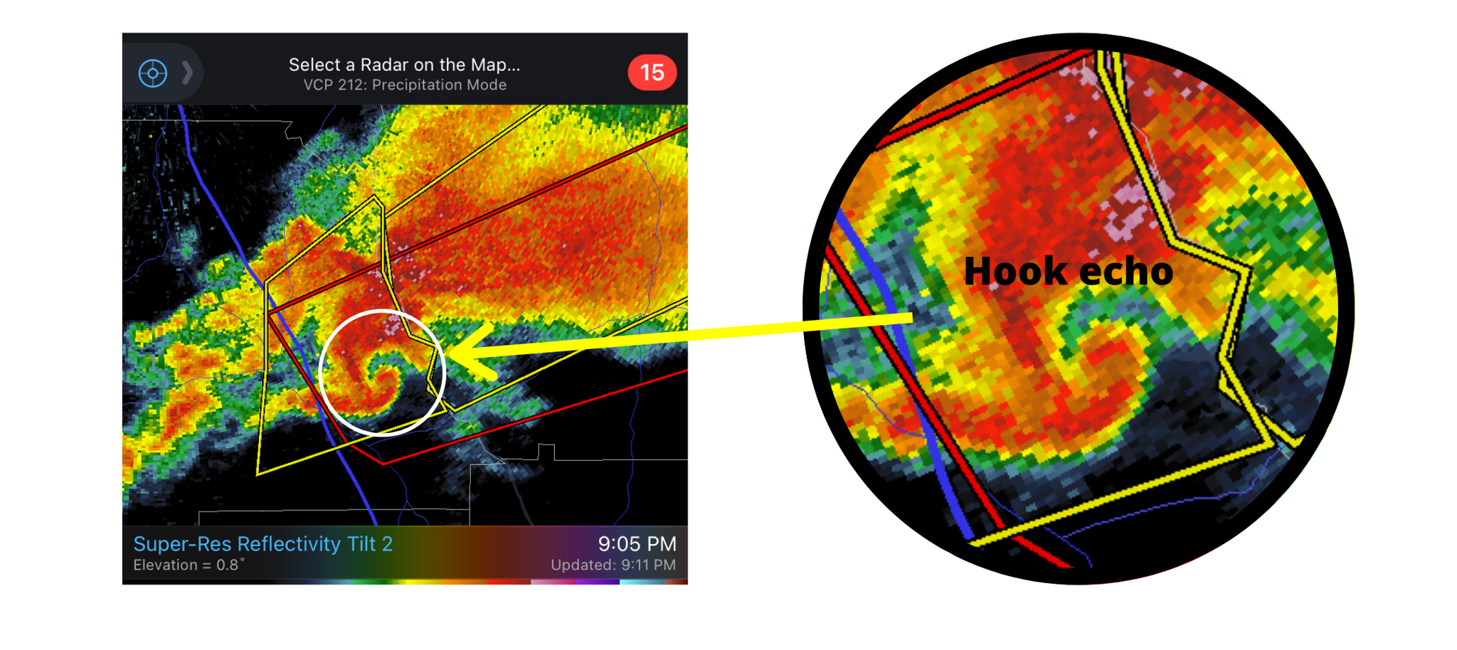
How do you know it's a supercell? Look for the distinguishable hook feature on the rear side of the storm, which is formed due to the interaction of the thunderstorm downdraft with the updraft. The hook echo is a good indication that the storm is rotating. If the counterclockwise circulation continues to strengthen and debris is present, likely a tornado is located in the hook.
Squall lines
If you look at a radar and see a group of thunderstorms in a line, that is a squall line. They produce large hail, strong winds, and occasionally tornadoes. Squall lines plow through an area quickly. They are only about 10 to 20 miles wide but can be hundreds of miles long, causing widespread damage as they move. They tend to form along cold fronts when wind shear induces lifting along the front leading to convection formation in a narrow band.
As strong winds rush into the line of thunderstorms from behind, it causes the convection line to bow out, and we get a bow echo, which is also known as a derecho. High winds are strongest where the storm is bowing out.
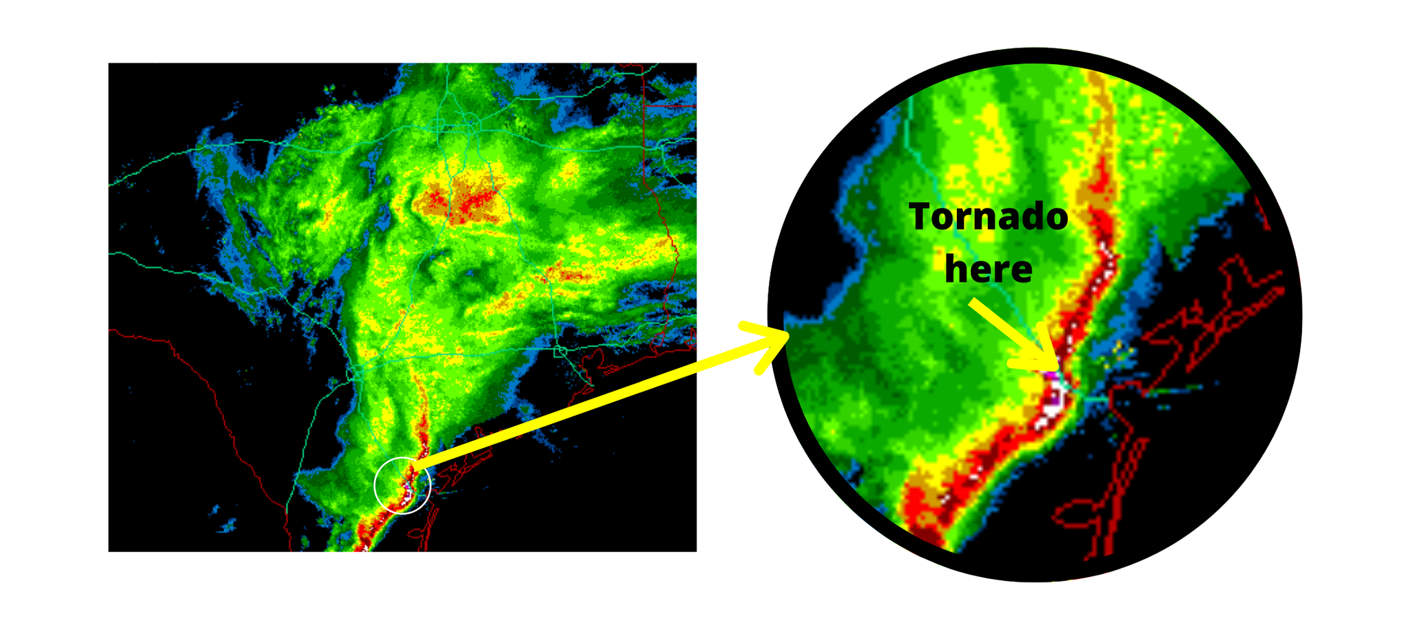
Another feature of this line of storms is notches of rotation (circled in the image below), which is found on the leading edge of the squall line. Those notches are an indication of embedded rotation and, if strong enough, a tornado may form within the notch. These tornadoes, while often short-lived, are responsible for severe damage. Tornado strength of EF0 or EF1 is common with squall lines.
Next week -
I briefly touched on squall lines, but these storms are just another name for Quasi-Linear Convective Systems (QLCS), which is further a sub-category of Mesoscale Convective Systems (MCS). However, MCS can also be broken down into Mesoscale Convective Complexes (MCC), or Mesoscale Convective Vortices (MCV). Confused? That's fine! Check back next week and I'll break it down.

0 Comments Add a Comment?