Why are we so cool and they're so hot
In mid-June, a heatwave hit the Ozarks. Temperatures sat in the 90s for days on end, and the humidity soared. During the same period, the southwest experienced a heatwave with skyrocketing temperatures in the triple digits.
The last week of June set up an even more unprecedented and dangerous heatwave over the Pacific Northwest. This heatwave was different. The region is not used to such temperature extremes. The heat was deadly, with news outlets reporting hundreds of deaths linked to extreme temperatures. Many homes in the northwest don't have air conditioning, leaving them unprepared for the heat.
HEAT WAVE
— NWS Seattle (@NWSSeattle) june"="">https://twitter.com/NWSSeattle... 25, 2021
This is expected to be unprecedented event. Those of us at the office have never seen PNW forecast data like this. We encourage everyone to make plans now to check in on and ensure their loved-ones, neighbors, pets, and the entire community remain safe and healthy #WAwx pic.twitter.com/xfKtw7IICR
From June 26th through the 29th, dozens of cities broke records for the extreme heat. Portland, OR. had temperatures reach 108° on June 26th, 112° on June 27th, and 116° on June 28th. This set all-time record highs for the city.
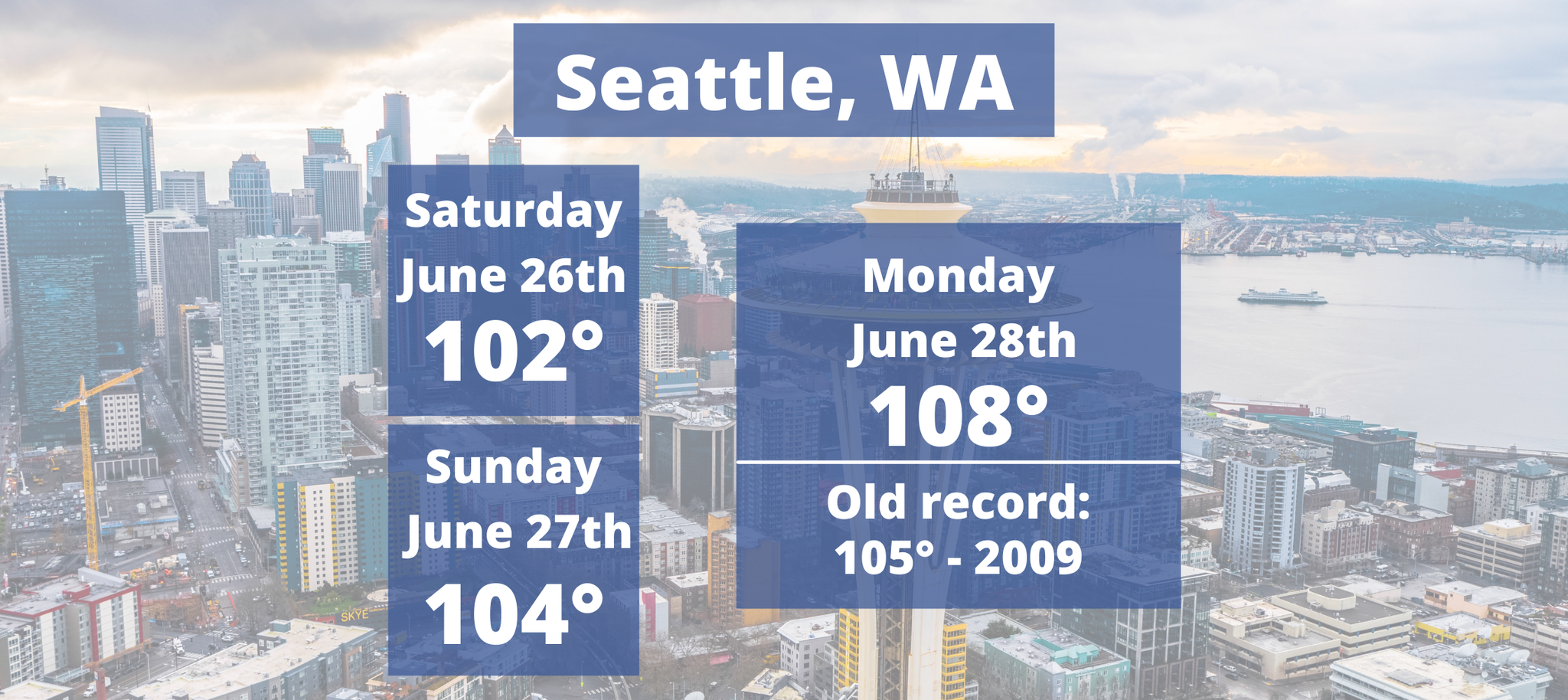
In the last 126 years, Seattle, WA. has only hit 100° three times. Last week, the city saw three consecutive days of triple-digit temperatures. Seattle hit 108° on Monday, the 28th, shattering the previous record of 105° set in July 2009.
Across the border, the heat also burned. Lytton, British Columbia, registered a temperature of 48° above what’s normal for this time of year.
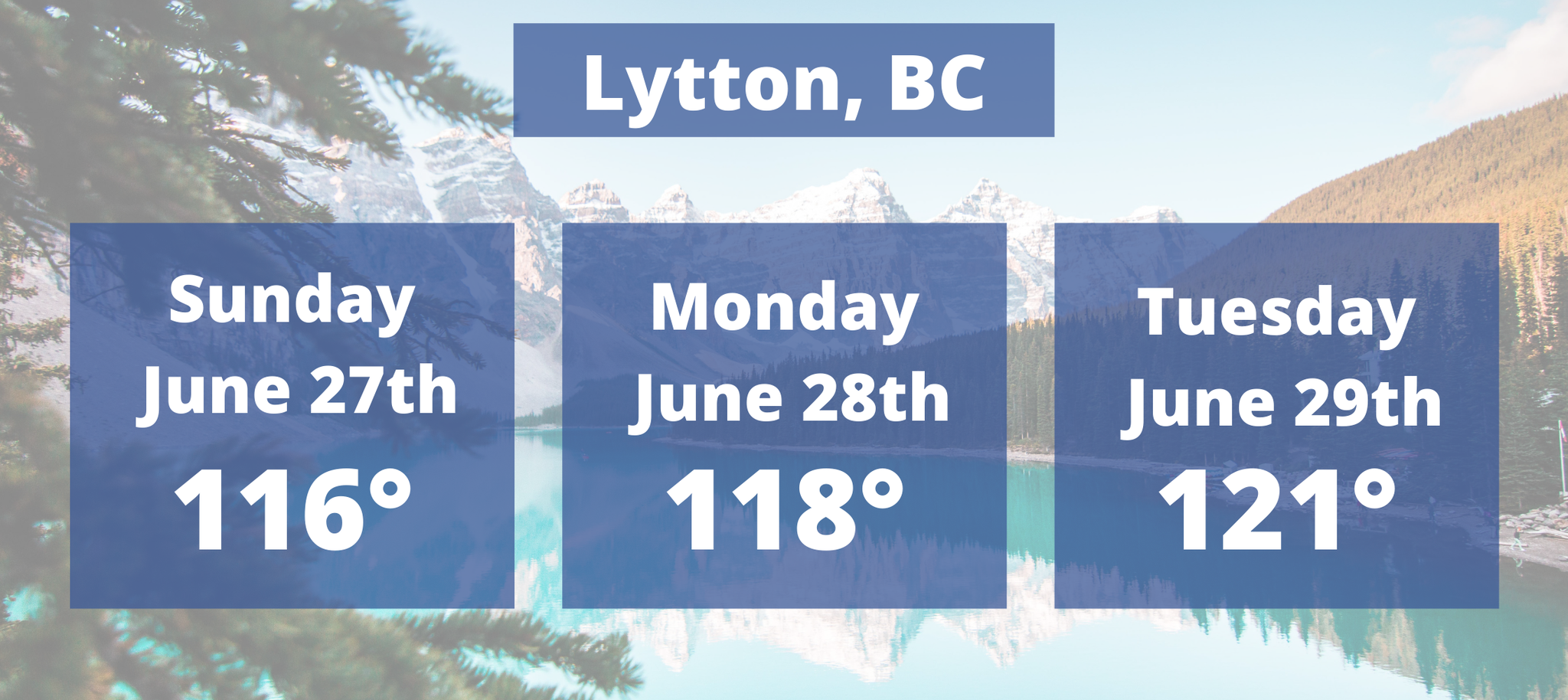
Temperatures Sunday, June 27th, hit 116° in Lytton. The highest temperature ever recorded in Canada. Think that’s hot? Well, come Monday, June 28th, that record was shattered when temperatures reached 118°. Then, on June 29th, the all-time hottest temperature ever recorded in Canada was broken a THIRD time when temperatures reached 121°. Not even Las Vegas has ever had temperatures this hot.
The National Weather Service reported that the heatwave brought widespread temperatures 30 to 40° above average across much of the Pacific Northwest. They called the heatwave “historic and dangerous.”
I just want to emphasize that these scorching temperatures in the Pacific Northwest are uncommon. Also uncommon, a heatwave so early in the summer.
So, what’s up with the weather? Why are they baking, but here in the Ozark’s we are experiencing some slightly below-average temperatures and low humidity?
Breaking it down
The main culprit for the hot weather in the Pacific Northwest was an anomalous high-pressure ridge over British Columbia and Washington that remained near stationary. In addition to the ridge, low pressure was found off of California’s coast. Take note of the image below depicting pressure height anomalies high up in the atmosphere. This compares how above or below average the forecasted pressure heights are compared to what is average. Pressure and temperature are related, so if you have anomalously high pressure, you can expect anomalously high temperatures and vice versa.
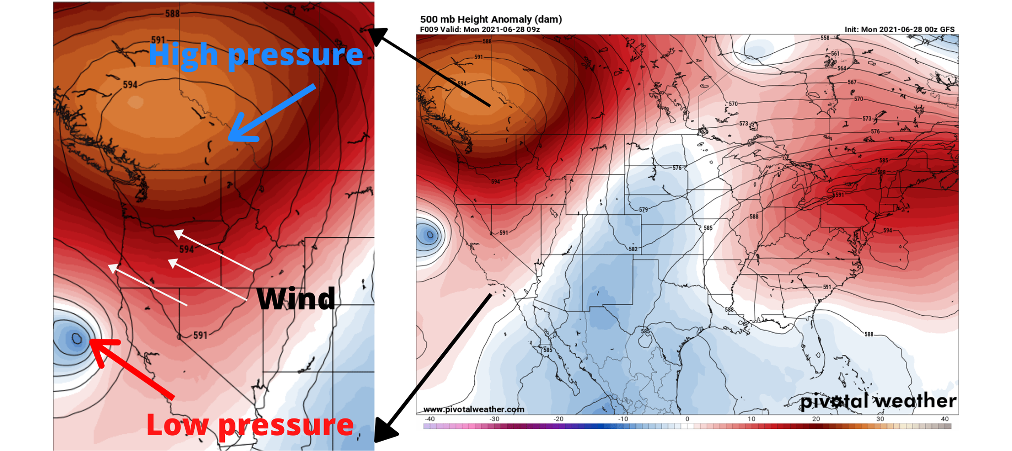
The air around high pressure blows clockwise in the Northern Hemisphere, while around the low-pressure air blows counterclockwise. These two circulations acted together to bring hot air from the southeast and flow towards the northwest.
A few things happened because of this. First, this kept cooler ocean air from moving inland and providing relief to the northwestern states. Topography also played a role. The northwest is a mountainous region, so easterly winds flowing over the mountains compress and heat up, resulting in downsloping winds and even hotter temperatures along the West Coast.
You may hear the term heat dome thrown about to describe the extreme heat in the northwest. A heat dome essentially is an area of high pressure that acts as a lid, trapping the heat at the surface.
The heat dome was lodged over the northwest because of the jet stream pinching the high pressure off from the main flow pattern. The jet stream flowed around the high and dived south, creating a trough over the Midwest. This caused rainy conditions in the Ozarks and also contributed to slightly below-average temperatures. For the northwest, this led to a prolonged high-pressure pattern.
What's next?
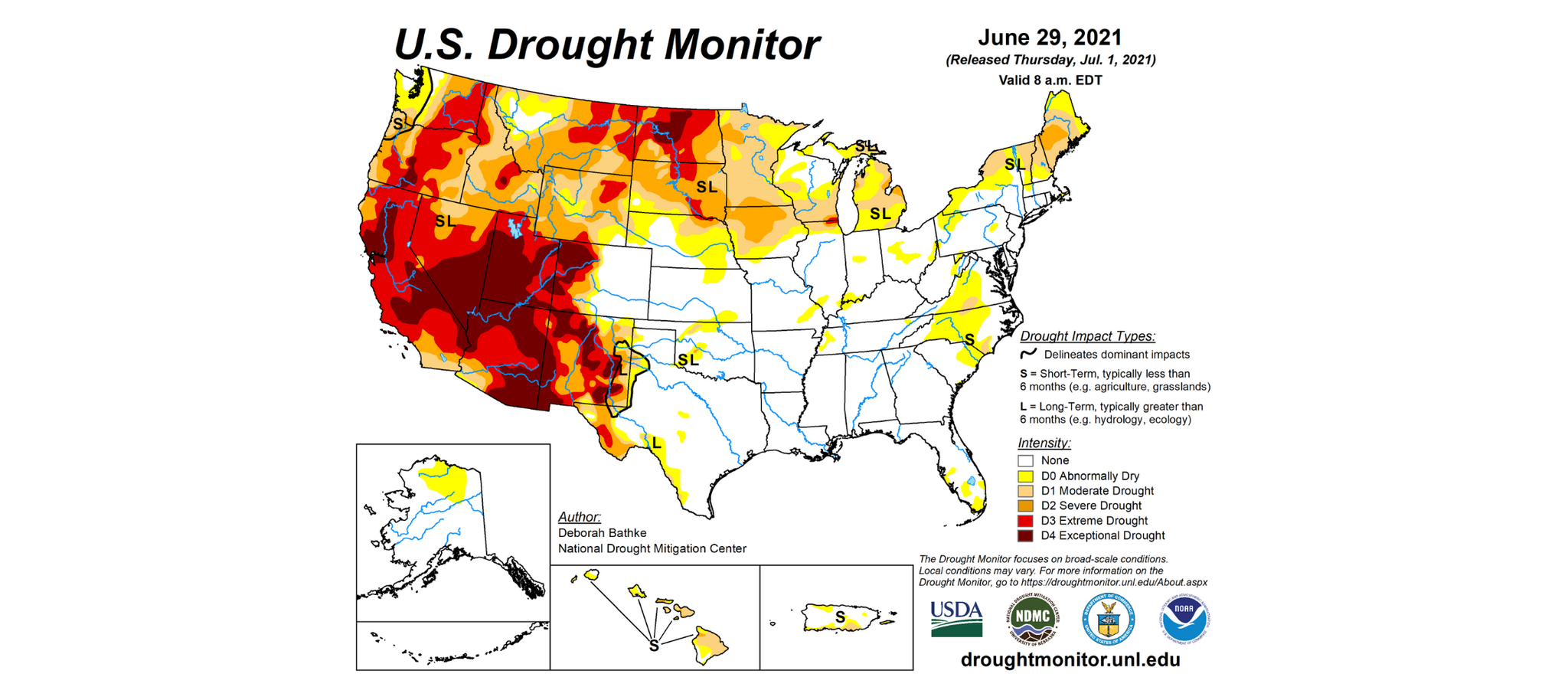
While temperatures in the northwest have lowered to more manageable levels, the extreme heat will have lingering impacts on extreme drought conditions and the wildfire season.
As of Friday, 93% of the west is experiencing drought conditions. Parts of Utah, Nevada, Arizona, and California are in the extreme drought category. A few storms are in the extended forecast, however, these storms raise concerns about lightning strikes causing more forest fires.
A change in the weather pattern is enough to end a heatwave. High pressure creating extreme temperatures either needs to break down or move out of an area, replacing the region with low pressure and cooler temperatures.
Ending a drought is more difficult. While soaking rain may provide temporary drought relief, the showers may not be enough to end the drought in the long term. A return to normal rainfall and snow patterns and amounts is what's necessary to allow all the rivers, lakes, and streams to reach normal levels.

1 Comment Add a Comment?
Mark
Posted on July 6, 2021, 4:43 a.m.
Leah, great info, I have not heard this elsewhere!